A budget-friendly GPS for hiking is not a compromise — it is a calculated decision to carry reliable satellite positioning without the advanced mapping features of premium models. The real challenge is finding a device that holds a signal under tree cover, delivers hours of battery life, and offers a durable build, all while staying lean on cost.
I’m Mohammad Maruf — the founder and writer behind WellFizz. My research on entry-level GPS devices focuses on satellite lock speed, battery endurance, and real-world portability for day hikers and overnight trekkers.
After sorting through dozens of budget-friendly personal locator beacons and handheld navigators, I built this guide to help you find the most reliable cheap gps for hiking that matches your trail needs without draining your wallet.
How To Choose The Best Cheap GPS For Hiking
At a sub- price point, you are trading premium topographic maps and high-refresh screens for core positioning reliability. The most critical factor is not the number of features but how well the device performs its primary job: maintaining a lock on multiple satellite constellations in varied terrain.
Satellite System Support (Multi-GNSS)
Single-band GPS receivers struggle in dense forest or deep valleys. Devices that support GPS, GLONASS, Galileo, and BeiDou simultaneously can lock onto signals faster and hold them longer under canopy. Multi-GNSS support is non-negotiable for a cheap GPS for hiking that you actually trust off-trail.
Battery Type and Runtime
Rechargeable lithium batteries keep initial costs low, but AA-powered units let you carry spares on multi-day trips. Look for at least 20 hours of continuous use in standard mode. Devices that offer an expedition or battery-save mode can stretch that to several days, which matters more than a large color display.
Waterproofing and Physical Durability
An IPX7 or IP66 rating means the device survives rain, river crossings, and accidental drops in mud. Rubberized casings and glove-friendly buttons add real-world resilience. A cheap GPS that fails in wet conditions is not cheap — it is wasted money.
Quick Comparison
On smaller screens, swipe sideways to see the full table.
| Model | Category | Best For | Key Spec | Amazon |
|---|---|---|---|---|
| Garmin eTrex SE | Handheld | Ultra-long battery trips | 168 hours standard mode | Amazon |
| Garmin eTrex 32x | Handheld | Preloaded topographic maps | 25 hours GPS mode | Amazon |
| Garmin GPSMAP 65s | Handheld | Multi-band accuracy | 16 hours standard mode | Amazon |
| Bushnell BackTrack Mini | Navigator | Simple point-to-point return | 35 hours battery life | Amazon |
| Spot Gen 4 | Messenger | Emergency SOS communication | Globalstar satellite network | Amazon |
| NiesahYan A6 | Handheld | Compact coordinate tracking | 20 hours rechargeable | Amazon |
| NiesahYan Topo GPS | Handheld | USA topographic maps | 36 hours battery life | Amazon |
| BEVA NB88 Survey | Survey | Land area measurement | ±0.002 acres accuracy | Amazon |
| ACR ResQLink 400 | PLB | Global emergency rescue | 406 MHz / GPS / Galileo | Amazon |
In‑Depth Reviews
1. Garmin eTrex SE

The Garmin eTrex SE delivers an extraordinary 168 hours of battery life in standard mode on two field-replaceable AA batteries, stretching to 1,800 hours in expedition mode. This alone makes it the endurance champion among budget-friendly hiking GPS units. Its 2.2-inch high-resolution display remains readable in direct sunlight, and multi-GNSS support (GPS, GLONASS, Galileo, BeiDou, QZSS) ensures reliable satellite locks under dense canopy.
Pairing with the Garmin Explore app unlocks wireless software updates, smart notifications, and Active Weather — features rarely seen at this price tier. The digital compass provides accurate bearings even when stationary, and the IPX7 waterproof rating means it survives heavy rain and stream crossings. Field-replaceable AA batteries let you carry spare power for multi-day trips, a major advantage over sealed rechargeable units.
The menu navigation takes some practice, and the device lacks preloaded topographic maps — you will rely on the app for detailed cartography. But if you want a rugged, long-lasting GPS that focuses on core tracking and positioning without breaking your budget, this is the clear winner among cheap GPS for hiking options.
Why it’s great
- Exceptional 168-hour battery life on two AA batteries
- Multi-GNSS support for reliable tracking under tree cover
- Bluetooth pairing with Garmin Explore app for trip planning
Good to know
- No preloaded topographic maps; requires smartphone app
- Buttons are stiff and menus feel clunky initially
2. Garmin eTrex 32x

Stepping up from the SE, the Garmin eTrex 32x adds preloaded Topo Active maps with routable roads and trails, a 3-axis compass, and a barometric altimeter — all in the same compact, rugged chassis. The 2.2-inch sunlight-readable color display (240 x 320 pixels) improves readability over monochrome screens, and the dual GPS + GLONASS support tracks reliably in challenging environments.
Battery life reaches up to 25 hours in GPS mode with two AA batteries, and the 8 GB internal memory plus micro SD slot lets you load additional maps or custom routes. Users consistently report accurate waypoint marking and reliable navigation in backcountry conditions, with one reviewer crediting the device for navigating out of thick brush during a medical emergency.
The learning curve is steep — the instruction manual is sparse, and you will likely rely on YouTube tutorials. The screen also has noticeable refresh lag. But for hikers who want built-in topographic mapping without relying on a smartphone app, the eTrex 32x offers the best balance of features and durability at a mid-range price.
Why it’s great
- Preloaded Topo Active maps with routable trails
- 3-axis compass and barometric altimeter
- 8 GB internal memory plus micro SD slot
Good to know
- Steep learning curve without clear instructions
- Noticeable screen refresh lag during use
3. Garmin GPSMAP 65s

The GPSMAP 65s is Garmin’s most affordable handheld with multi-band GNSS technology, which provides sub-6-foot accuracy in steep terrain, urban canyons, and dense forests. The large 2.6-inch sunlight-readable color display makes map reading comfortable, and the button-operated interface works perfectly with gloves. Preloaded TopoActive maps and federal public land boundaries (U.S.) are included out of the box.
A 3-axis compass and barometric altimeter support go-anywhere navigation, and compatibility with the Garmin Explore app lets you manage tracks, routes, and waypoints. Battery life ranges from 10 to 27 hours depending on backlight and satellite mode, with standard AA batteries allowing easy field replacement. Users consistently praise the accuracy and fast satellite acquisition, though the software ecosystem — BaseCamp and multiple Mac apps — requires patience to master.
The GPSMAP 65s costs more than entry-level models, but its multi-band performance justifies the investment for hikers who frequently travel through challenging terrain. If you need professional-grade accuracy without paying for an inReach subscription, this is the budget-friendly choice.
Why it’s great
- Multi-band GNSS for ~6 ft accuracy in dense cover
- Large 2.6″ sunlight-readable color display
- Preloaded TopoActive and public land maps
Good to know
- Software setup with BaseCamp can be frustrating
- Battery life varies significantly with backlight settings
4. Bushnell BackTrack Mini

The Bushnell BackTrack Mini focuses on one core task: capturing your starting point and guiding you back. It uses GPS to save waypoints and then provides directional arrows back to your trailhead or basecamp. Battery life reaches up to 35 hours on a single charge, and the glove-friendly buttons and easy-to-read display make operation simple even in bad weather.
Bluetooth connectivity lets you sync trips and waypoints to the Bushnell Connect app, and the device also displays elevation gain/loss, barometric pressure, and sunrise/sunset times. The IPX7 waterproof rating ensures it survives rain and splashes, and the micro USB charging is convenient for overnight trips.
Accuracy issues are reported — some users note distance overestimates of up to 60 percent and elevation readings that can be off by hundreds of feet. The companion app has mixed reviews, and the micro USB port feels outdated. For hikers who only need a reliable breadcrumb trail back to the car and do not require detailed mapping, the BackTrack Mini works. For serious navigation, look elsewhere.
Why it’s great
- Simple, focused return-to-start navigation
- 35-hour battery life on rechargeable battery
- Glove-friendly buttons and clear display
Good to know
- Reported distance and elevation accuracy issues
- Companion app functionality is inconsistent
5. Spot Gen 4 Satellite GPS Messenger

The Spot Gen 4 is a satellite messenger first and a GPS tracker second. It uses the Globalstar satellite network to send check-in messages, custom texts, and SOS alerts to emergency responders — no cell service required. This makes it ideal for hikers venturing far beyond cell towers who want a lifeline for family or rescue services.
The device is lightweight (142 grams) and includes a carabiner for easy attachment to a pack strap. It uses four AA batteries (included) and offers two subscription plans: the low-cost Flex plan for occasional use and a standard plan for frequent trips. The tracking feature transmits location updates when moving and when stopped, and the SOS button sends GPS coordinates to emergency services.
A subscription is required for any functionality, and the interface can be confusing — several users recommend watching setup videos rather than relying on the printed instructions. The device does not provide turn-by-turn navigation or mapping; it is strictly a one-way communication tool. If you need emergency communication and basic location sharing, the Spot Gen 4 is the most affordable satellite messenger available.
Why it’s great
- Global satellite SOS and messaging without cell service
- Lightweight and pack-friendly with carabiner
- Cost-effective Flex subscription for occasional users
Good to know
- Requires ongoing subscription for any function
- No navigation or mapping — communication only
6. NiesahYan A6 Handheld GPS

The NiesahYan A6 is a no-frills GPS tracker that records coordinates, tracks your route, and guides you back to your starting point. It supports four satellite systems (GPS, Galileo, BeiDou, QZSS) for fast positioning, and the 2.4-inch sunlight-readable color screen is bright enough for daytime use. The rechargeable battery provides up to 20 hours of continuous operation, and USB-C charging is a welcome modern touch.
This device comes with essential tools: a GPS compass, barometric altimeter, and sunrise/sunset times. It does not include any maps — it is purely a coordinate and compass-based navigator. You must acquire satellite signals in an open sky area before heading into the backcountry, and the accuracy can degrade on steep winding trails.
The menu system requires dedicated study to navigate, and several users note the lack of map support makes it unsuited for routed navigation. It is best used as a backup tracker or for hikers comfortable reading coordinates and compass bearings. At this price point, it provides reliable positioning without the complexity of full map systems.
Why it’s great
- Compact and lightweight with USB-C charging
- Bright 2.4″ sunlight-readable color screen
- Multi-GNSS support for reliable satellite locks
Good to know
- No built-in maps — coordinate tracking only
- Accuracy varies on steep, winding terrain
7. NiesahYan Topo GPS Navigator

The NiesahYan Topo GPS Navigator is one of the few budget devices that ships preloaded with USA topographic maps. The 3.2-inch sunlight-readable color screen is larger than most competitors, and the 32 GB of internal memory leaves ample room for additional map downloads. Multi-GNSS support (GPS, Galileo, BeiDou, QZSS) provides positional accuracy within 6 feet, and the IP66 water resistance handles rain and splashes.
Battery life reaches 36 hours on a full charge via USB-C, making it suitable for multi-day trips. A 3-axis compass and barometric altimeter support navigation even when stationary, and the physical button interface works well in wet or cold conditions. The ability to record tracks and navigate back to waypoints is straightforward.
Several users report reliability issues — one device failed to boot after its first field test, and others note poor instruction quality. The operating system and menu logic are not as polished as Garmin’s, but for hikers who want preloaded US topo maps without paying Garmin prices, this device offers strong value. Consider it a capable backup or primary GPS for established trails.
Why it’s great
- Preloaded USA topographic maps out of the box
- Large 3.2″ sunlight-readable screen
- 36-hour battery life with USB-C charging
Good to know
- Some users report reliability issues after field use
- Instructions quality is lacking
8. BEVA NB88 Handheld Survey GPS

The BEVA NB88 is designed primarily for land area measurement rather than hiking navigation. It supports four satellite positioning systems (GPS, BeiDou, GLONASS, QZSS) and claims accuracy within ±0.002 acres for area measurements. The 3.2-inch anti-glare TFT display remains readable in bright midday sun, and the rubberized case provides a comfortable, secure grip.
Multiple measurement modes handle farmland, gardens, parking lots, and pastures, and it also supports distance and slope measurement. The device is waterproof and dustproof, surviving sudden storms and muddy job sites. It targets surveyors, ranchers, and landowners rather than trail hikers.
Accuracy is inconsistent — one user reported errors of several meters on a 7-point test course, and the device lacks elevation data. The LED indicator cannot be turned off, and the menu system is confusing without a manual in English. If you need area measurement for property or agricultural use, it offers value. For hiking navigation, skip this and choose a dedicated trail GPS.
Why it’s great
- High-accuracy area measurement for land survey
- Rugged waterproof rubberized construction
- Large anti-glare 3.2″ TFT display
Good to know
- Not designed for hiking navigation
- Inconsistent measurement accuracy reported
9. ACR ResQLink 400
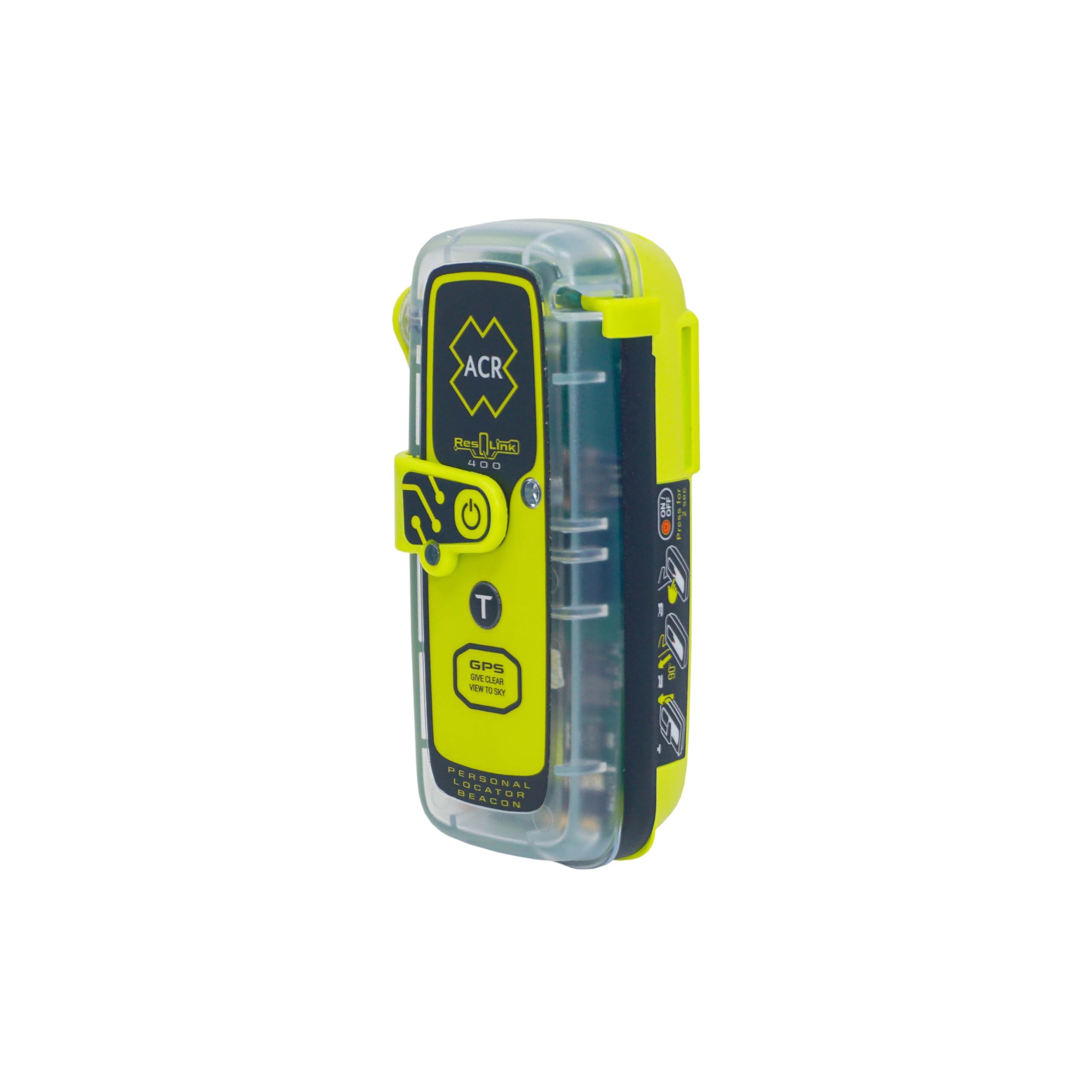
The ACR ResQLink 400 is a Personal Locator Beacon (PLB) that uses the global Cospas-Sarsat and MEOSAR satellite systems to alert search and rescue — no subscription required. It transmits a 406 MHz distress signal along with your GPS and Galileo position, allowing rescuers to pinpoint your location anywhere on Earth. An LED strobe and infrared strobe provide visibility in low-light conditions.
The device is compact (5.28 ounces) and comes with a belt clip, PFD inflation tube clip, and attachment strap. The battery is non-replaceable but lasts 5+ years in standby and meets regulatory requirements. Users highlight its peace of mind for ocean kayaking, offshore sailing, and remote hiking where cell service is non-existent.
This is not a navigation device — it does not provide maps, waypoints, or directional guidance. It is a dedicated emergency beacon that should be carried alongside a handheld GPS. The upfront cost is higher, but the lack of ongoing subscription fees makes it cost-effective over time for backcountry explorers who prioritize rescue capability above all else.
Why it’s great
- Global satellite rescue with no subscription fees
- Compact, lightweight, and waterproof design
- GPS and Galileo position transmitted with distress signal
Good to know
- Emergency beacon only — no navigation features
- Battery not user-replaceable (5+ year life)
FAQ
Can I use a cheap GPS for hiking without a subscription?
Why does my budget GPS lose signal under tree cover?
Is a GPS with preloaded topo maps worth the extra cost?
What battery type lasts longer for multi-day hikes?
Final Thoughts: The Verdict
For most hikers, the best cheap gps for hiking winner is the Garmin eTrex SE because it delivers unmatched battery life, reliable multi-GNSS tracking, and Bluetooth connectivity at a price that undercuts most competitors. If you want preloaded topographic maps and a compass in the same package, grab the Garmin eTrex 32x. And for backcountry explorers who need global emergency rescue capability without subscription fees, nothing beats the ACR ResQLink 400.

Mo Maruf
I created WellFizz to bridge the gap between vague wellness advice and actionable solutions. My mission is simple: to decode the research and give you practical tools you can actually use.
Beyond the data, I am a passionate traveler. I believe that stepping away from the screen to explore new environments is essential for mental clarity and physical vitality.