A dead battery and a blank screen are the worst sounds in the backcountry. A dedicated backpacking GPS—separate from your phone—delivers the redundant navigation and satellite connectivity that keeps your trip on track when cell service drops to zero. Choosing the wrong one means fighting with a confusing interface when you should be watching the sunset.
I’m Mohammad Maruf — the founder and writer behind WellFizz. I’ve parsed hundreds of spec sheets, customer durability reports, and satellite communication benchmarks to find the handhelds that actually perform when you need a coordinate fix miles from the nearest trailhead.
Whether you’re marking waypoints for a week-long trek or need two-way SOS messaging for solo alpine routes, this guide to the best backpacking gps units will help you match the right satellite engine and interface to your specific terrain.
How To Choose The Best Backpacking GPS
A backpacking GPS is a specialized tool that balances satellite reception, battery endurance, map detail, and physical durability. Unlike a phone app, your handheld must survive drops, rain, and freezing temps while maintaining a lock in dense tree cover. Focus on these three factors to find the right unit for your trip length and terrain complexity.
Satellite Systems & Signal Reliability
The GPS constellation alone is reliable in open country, but deep valleys and heavy canopy degrade accuracy fast. Look for multi-GNSS support that includes GLONASS, Galileo, BeiDou, and QZSS. Units that lock onto multiple constellations maintain a fix and shorten acquisition time in environments where a single-system device would drop to a blinking search.
Battery Architecture & Field Life
AA-powered units let you swap cells from a resupply box, while internal rechargeable batteries shave weight but require a power bank. Pay attention to the difference between standard mode and expedition or battery-save mode—the latter can extend run time from 25 hours to over 100 hours by reducing the refresh rate and dimming the display. The best backpacking GPS units give you both options so you can match power draw to the day’s navigation intensity.
Map Quality & Storage
Preloaded topo maps with routable trails save you from downloading tiles before a trip. Internal memory and a microSD slot let you load additional regional or satellite imagery. A sunlight-readable color screen with at least 240 x 320 pixels makes contours and trail junctions legible without squinting. Units without expandable storage lock you into whatever basemap came preinstalled.
Quick Comparison
On smaller screens, swipe sideways to see the full table.
| Model | Category | Best For | Key Spec | Amazon |
|---|---|---|---|---|
| Garmin eTrex 32x | Mid-Range | Multi-day hikes with topo maps | 8 GB memory + microSD slot | Amazon |
| Garmin GPSMAP 86Sci | Premium | Off-grid SOS + marine charting | inReach satellite messaging | Amazon |
| Spot X | Mid-Range | Two-way texting outside cell range | Globalstar satellite network | Amazon |
| Garmin GPSMAP 79sc | Premium | Coastal paddling with BlueChart | Preloaded BlueChart g3 charts | Amazon |
| Garmin eTrex SE | Budget-Friendly | Entry-level geocaching & day hikes | 168 hrs standard mode battery | Amazon |
| Garmin GPS 73 | Budget-Friendly | Marine waypoint navigation | 1,000 waypoint storage | Amazon |
| Bushnell BackTrack Mini | Budget-Friendly | Simple backtrack utility | 35 hr rechargeable battery | Amazon |
| Garmin GPSMAP 79s | Premium | Rugged marine backup nav | 10,000 waypoint capacity | Amazon |
| Garmin RV 1095 | Premium | RV-specific road routing | 10-inch touchscreen display | Amazon |
In‑Depth Reviews
1. Garmin eTrex 32x

The eTrex 32x hits the sweet spot for backcountry hikers who need preloaded Topo Active maps and a 3-axis compass with barometric altimeter. The 2.2-inch sunlight-readable color display (240 x 320 pixels) makes trail junctions and contour lines clear even under direct sun, and the button-only interface works perfectly with gloved hands in cold weather. Multi-GNSS support (GPS + GLONASS) locks on faster in steep valleys where single-system units hunt for a signal.
Battery life delivers roughly 25 hours in standard GPS mode using two AA cells, but many owners report exceeding 50 hours in battery-save mode by disabling WAAS and reducing backlight. The 8 GB of internal memory plus a microSD slot lets you load additional regional topo or satellite imagery without deleting existing maps. One known quirk: OpenStreetMap .img files placed directly in the “Garmin” folder can cause the unit to freeze; keep those files on the microSD card instead.
The combination of reliable satellite lock, expandable storage, and a compass that works while stationary makes the 32x a true trail companion. It is not the cheapest handheld Garmin makes, but the map quality and sensor package justify the step up from entry-level models.
Why it’s great
- Preloaded Topo Active maps with routable trails
- 3-axis compass and barometric altimeter onboard
- Glove-friendly button navigation
Good to know
- Learning curve with Garmin menu logic
- Screen refresh lag reported in dense map zooms
2. Garmin GPSMAP 86Sci

The GPSMAP 86Sci is one of the few handhelds that combines marine-grade navigation with satellite SOS messaging via the 100% global Iridium network. The 3-inch sunlight-visible display and button operation keep it usable in spray and rough seas, while the floating design means a drop overboard doesn’t end your trip. Preloaded BlueChart g3 coastal charts merge Garmin and Navionics data so you can identify channels, hazards, and depths without loading separate cards.
Battery life sits at around 24 hours in GPS mode, but the real value is two-way texting and an interactive SOS button that sends your coordinates to a 24/7 search and rescue center. The unit can also stream boat data from compatible chartplotters and function as a remote for Garmin autopilots and Fusion audio—a bonus for cruisers who want a consolidated helm. The Iridium subscription is separate and adds a recurring cost, but for solo coastal paddlers or offshore sailors, that link is worth the fee.
Owners describe a steep learning curve for the menu system, and the screen is smaller than it looks in product photos. If you mostly hike inland, the inReach capability is overkill; but if you cross between land and water on multi-week trips, the 86Sci is the most capable dual-environment tool in this list.
Why it’s great
- Global Iridium satellite SOS and texting
- Floats and is water-resistant to IPX6
- Preloaded BlueChart g3 coastal charts
Good to know
- Satellite subscription adds ongoing cost
- Small screen given the overall unit size
3. Spot X

The Spot X is a dedicated two-way satellite messenger that works over the Globalstar network, letting you send and receive texts from any cell number or email when you are beyond cell towers. The integrated SOS button connects to a 24/7 search and rescue monitoring center, and the device can transmit your GPS coordinates to pre-set contacts on a schedule. With a quoted battery life of up to 240 hours in standby (10 days of 10-min tracking), it is built for extended trips where you need daily check-ins rather than constant nav.
The keypad and small monochrome display are functional but not fast—each message takes around three minutes to send in the backcountry, and the buttons feel slow compared to a touchscreen. Close proximity to 5G cell towers can block message reception, so the Spot X performs best in truly remote areas. The subscription cost ranges roughly –30 per month depending on the plan (flex, basic, or unlimited), which adds a recurring expense that a standard GPS does not require.
If your primary need is staying in touch with family during a thru-hike or having a reliable SOS trigger for solo mountaineering, the Spot X fills that gap without needing a full mapping handheld. For pure navigation with detailed topo maps, you will still want a dedicated unit like the eTrex 32x alongside it.
Why it’s great
- Two-way satellite messaging outside cell range
- Long standby battery life for multi-week trips
- 24/7 SOS monitoring center access
Good to know
- Subscription required for all messaging
- Small keypad and slow text entry
4. Garmin GPSMAP 79sc

The GPSMAP 79sc is the marine-focused sibling of the standard 79s, adding preloaded BlueChart g3 coastal charts that include detailed depth contours, nav aids, and harbor data. It floats, carries an IPX6 water resistance rating, and features a high-resolution color display with scratch-resistant glass—critical for kayak and small-boat use where splashes are constant. Multi-GNSS support (GPS, GLONASS, BeiDou, Galileo, QZSS, and SBAS) ensures the unit maintains a fix even when you are bouncing through chop near cliff walls.
Waypoint capacity jumps to 10,000, and you can store 250 routes and 300 fit activities, making it easy to mark fishing spots, anchorages, and launch points over multiple seasons. The 3-axis tilt-compensated compass shows heading while you are stationary, and the barometric altimeter tracks pressure trends to help predict weather changes. Battery life runs around 20 hours in GPS mode with two AA batteries, which is sufficient for a long day on the water but falls short of the endurance-focused eTrex line.
Some owners find the scrolling button interface touchy, and the screen is smaller than a dedicated chartplotter, so it works best as a backup to a fixed helm unit. For coastal paddlers and day sailors who want marine-grade charts in a floatable handheld, the 79sc delivers specialized capability that pure hiking units cannot match.
Why it’s great
- Preloaded BlueChart g3 coastal charts
- 3-axis compass and barometric altimeter
- Floats in water and resists fogging
Good to know
- Button scrolling can be imprecise
- No inland lake maps without subscription
5. Garmin eTrex SE

The eTrex SE is the entry-level handheld that punches above its weight on battery stamina. Rated at 168 hours in standard mode and up to 1,800 hours in expedition mode with two AA batteries, it will outlast any other device on this list during a thru-hike, allowing resupply boxes to be spaced weeks apart. The 2.2-inch sunlight-readable display is sharp enough for basic navigation, and multi-GNSS support—including GPS, GLONASS, Galileo, BeiDou, and QZSS—keeps the track log accurate under heavy canopy.
Pairing with the Garmin Explore app on a smartphone brings wireless trip planning, active weather, smart notifications, and additional mapping without needing to cable up. The digital compass provides heading even when you are standing still, and the IPX7 water-resistant rating handles rain crossings and stream splashes. A built-in geocaching live feed automatically updates cache descriptions and logs when the phone is paired.
The SE lacks preloaded topo maps—you rely on the phone app for detailed terrain overlays—and the button stiffness has drawn comments from some owners. It is also limited to 1,000 cache entries in geocaching mode. If you want the simplest, longest-running tracker for solo trips where battery life is the priority over map detail, the eTrex SE is the right choice.
Why it’s great
- Extremely long battery life in expedition mode
- Multi-GNSS for better signal lock
- Wireless connectivity with Garmin Explore app
Good to know
- No preloaded topo maps onboard
- Stiff buttons not ideal for rapid use
6. Garmin GPSMAP 79s

The GPSMAP 79s is a rugged floating handheld that brings a worldwide basemap and upgraded memory for 10,000 waypoints, 250 routes, and 300 fitness activities. The scratch-resistant, fogproof glass and IPX6 water resistance mean it can live on a kayak deck or in a wet pocket without concern. Multi-GNSS support (GPS, GLONASS, BeiDou, Galileo, QZSS, and SBAS) provides reliable tracking around the globe, and the 3-axis tilt-compensated compass works while stationary—no need to hold the device level to get a bearing.
The barometric altimeter tracks pressure changes to refine altitude readings and can hint at incoming weather. Battery life sits at around 20 hours in GPS mode with two AA batteries, which is average for this category but acceptable given the ruggedized housing. The 79s does not include preloaded marine charts or satellite messaging, so it is best used as a durable navigation backup for expeditions where the primary concern is reliability over specialized mapping.
Some owners note that the housing lanyard attachment point can cause the unit to slide around on a flat deck, and the interface is identical to previous 78-series models—familiar but not redesigned. If you need a floating GPS that holds thousands of waypoints and runs on user-replaceable batteries, the 79s delivers proven Garmin durability without the subscription costs of the inReach models.
Why it’s great
- Floats and resists water immersion
- High waypoint and route capacity
- 3-axis compass and barometric altimeter
Good to know
- No preloaded marine or topo charts
- Lanyard housing design can slide
7. Garmin GPS 73
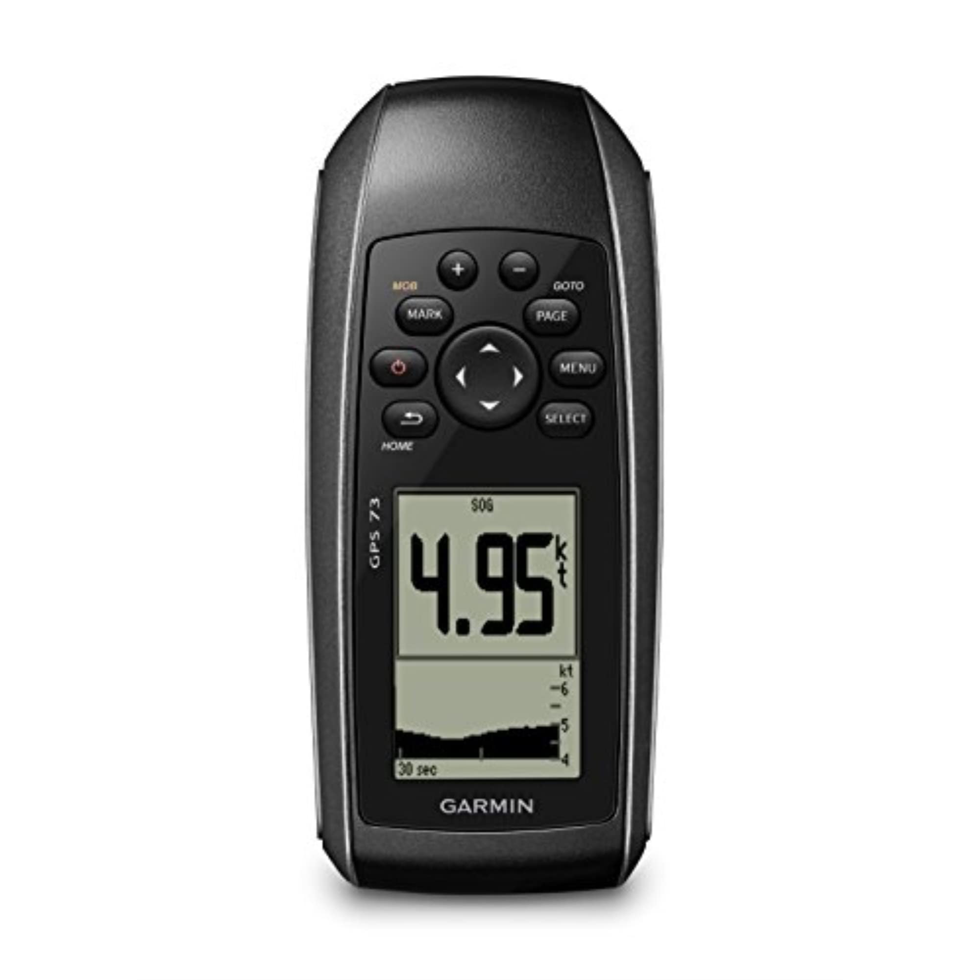
The GPS 73 is a purpose-built marine GPS that strips away backcountry mapping in favor of dedicated sailing tools. It includes a virtual starting line, countdown timers, tack assist, and speed history—features that competitive sailors and racers will use every race day. The intuitive user interface with dedicated backlit buttons makes operation straightforward even in spray, and the device stores up to 1,000 waypoints and 100 tracks to log marks, drifts, and anchor spots.
Battery life reaches about 18 hours on two AA batteries, and the 2.6-inch display is easy to read from a helm position without squinting. The GPS 73 does not have a color screen, preloaded charts, or satellite connectivity—it is purely a coordinate and course tool meant to complement paper charts. The position update rate is adjustable down to one-second intervals, which gives responsive speed and heading data during maneuvers.
Some owners note the unit is slow to update position compared to newer 78/79 models, and the lack of any map display means you cannot see your location relative to land features. If you are a recreational boater or sailor who wants a dedicated backup to a larger chartplotter, the GPS 73 is a focused, no-nonsense tool that does one thing well.
Why it’s great
- Built-in sailing features (virtual start, tack assist)
- Simple interface with dedicated buttons
- Adjustable position update rate
Good to know
- No color screen or map display
- Slower position refresh than newer models
8. Bushnell BackTrack Mini

The Bushnell BackTrack Mini is a minimalist GPS designed specifically for one job: guiding you back to your trailhead or basecamp. It captures a starting waypoint and shows a compass arrow and distance to that point, plus elevation gain and loss, barometric pressure, and sunrise/sunset times. The rechargeable battery runs up to 35 hours, and the rugged IPX7 waterproof body handles rain and drops without needing replacement AA cells.
Large, glove-friendly buttons control the mono LCD display, and Bluetooth syncs with the Bushnell Connect app for storing and sharing trips. The device does not provide turn-by-turn navigation or map overlays—it is a directional reference that confirms you are heading the right way after a day of off-trail exploring. Some owners have reported that the distance readings can overestimate by up to 60 percent, and elevation accuracy has been questioned in head-to-head comparisons with topo maps.
Setup can be finicky: the quick-start guide is minimal, and the full manual requires an online download. For a hiker who already uses a mapping app on a phone and just wants a dead-simple backup to verify direction, the BackTrack Mini is lightweight and straightforward. As a primary navigation tool for complex routes, however, its lack of maps and mixed accuracy make it a secondary device.
Why it’s great
- Simple one-button backtrack functionality
- Long rechargeable battery life
- Rugged, waterproof, and lightweight
Good to know
- No mapping or turn-by-turn guidance
- Distance and elevation accuracy concerns
9. Garmin RV 1095

The Garmin RV 1095 is a 10-inch RV-specific navigator that customizes routes based on your vehicle’s height, weight, length, and width—avoiding low bridges, sharp turns, and weight-restricted roads. The bright, high-resolution touchscreen supports landscape or portrait orientation and displays high-resolution Birdseye satellite imagery so you can preview campground layouts and tight approach roads before you commit. The preloaded directory includes RV parks, KOA sites, U.S. national parks, and Tripadvisor ratings right on the screen.
Road warnings pop up for steep grades, sharp curves, and weight limits, and the Garmin Drive app integration adds real-time weather ahead, traffic monitoring, and parking availability at Pilot and Love’s Travel Centers. The RV 1095 runs on internal rechargeable power when unplugged, but it is designed primarily as a dashboard-mounted driving companion rather than a handheld trail device. It does not include satellite SOS, topo mapping, or replaceable AA batteries—it is a road tool, not a backcountry GPS.
Some owners caution that the UI takes time to learn and that Bluetooth disconnections can interrupt traffic data. The unit also cannot access a Mac file system directly (Android-based, WiFi workaround needed for map transfers). For RVers who need safe routing for their rig and want to see campground amenities without flipping through apps, the 1095 is the most capable road-focused unit here, but it occupies a totally different category from the hiking GPS units elsewhere on this list.
Why it’s great
- Custom routing for RV height, weight, and length
- Large 10-inch high-res touchscreen
- Preloaded RV park and campground directory
Good to know
- Steep learning curve for the interface
- Bluetooth connectivity can be intermittent
FAQ
Can I use a backpacking GPS without a phone or subscription?
How do AA battery choices affect GPS performance?
Do I need preloaded topo maps or just waypoint logging?
Final Thoughts: The Verdict
For most users, the best backpacking gps winner is the Garmin eTrex 32x because it balances preloaded topo maps, a 3-axis compass and altimeter, expandable memory, and reliable AA battery life in a glove-friendly button package. If you want two-way satellite SOS for solo trips in remote alpine terrain, grab the Garmin GPSMAP 86Sci. And for a simple, lightweight backup that just shows you the direction back to camp, nothing beats the compact Bushnell BackTrack Mini.

Mo Maruf
I created WellFizz to bridge the gap between vague wellness advice and actionable solutions. My mission is simple: to decode the research and give you practical tools you can actually use.
Beyond the data, I am a passionate traveler. I believe that stepping away from the screen to explore new environments is essential for mental clarity and physical vitality.